

Bikepackia
EuroVelo · Ireland

The wild Atlantic coast, a flat run between the cities.

Two signed EuroVelos cross Ireland — the ~2,300 km Atlantic Coast Route up the rugged south and west seaboard, the cyclist's counterpart to the Wild Atlantic Way, and the flat Galway to Dublin Cycleway over the midlands on canal towpaths and old railways. One is a long, exposed expedition; the other an all-abilities greenway crossing. Explore them, then send one straight to the planner.

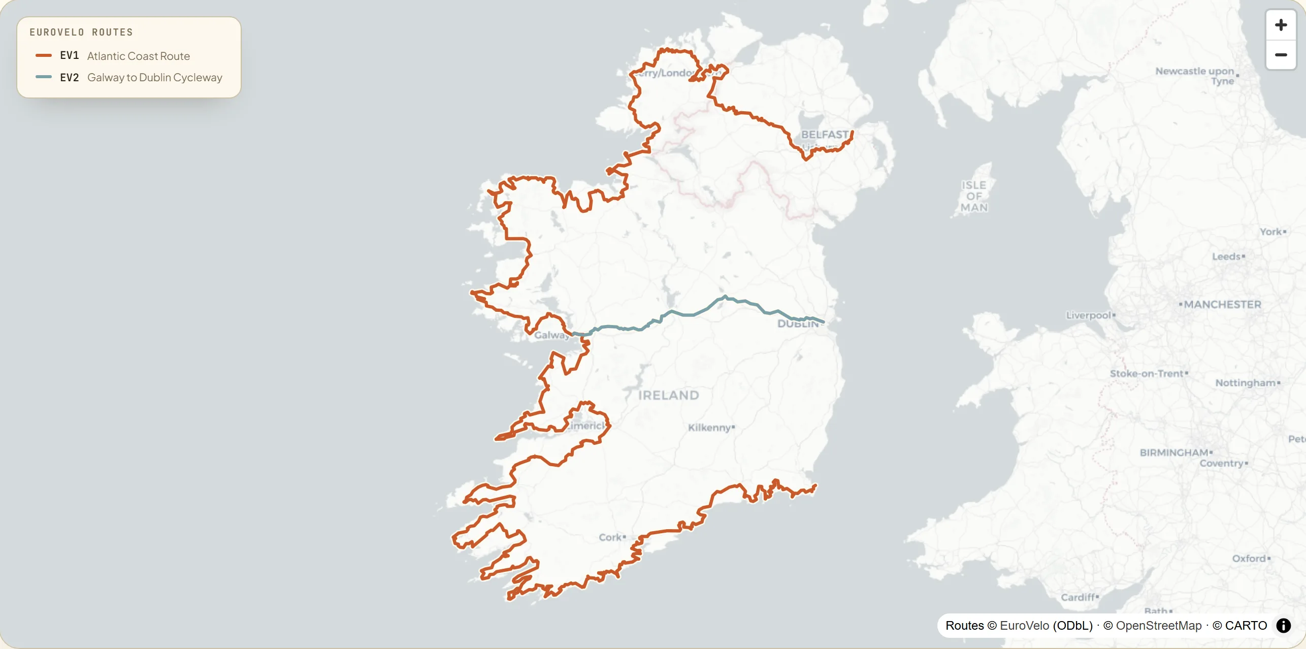
Map of the island of Ireland with two signed EuroVelo routes — the Atlantic Coast Route (EV1) from Rosslare Harbour up the south and west coasts through Cork, the Cliffs of Moher, Connemara and Donegal to Derry/Londonderry, and the Galway to Dublin Cycleway (EV2) running flat across the midlands from Dublin through Mullingar and Athlone to Galway.
2
national routes
~2,530 km
EuroVelo signed
60%
traffic-free on EV2
Why Ireland

Two EuroVelos — one wild, one flat.

Ireland has no single national route-number scheme like Denmark's signed "N"-routes. Instead it has a growing patchwork of signposted greenways (each 20–130 km), quiet signed road routes and the two EuroVelos, coordinated by Cycling Ireland — the national governing body and Ireland's EuroVelo coordination centre — and published on the official platform, euroveloireland.ie. The traffic-free backbone is built on disused railway lines and canal towpaths, like the 100 km-plus Royal Canal Greenway.

The headline is EuroVelo 1, the Atlantic Coast Route — the cyclist's counterpart to the Wild Atlantic Way driving route, running around 2,300 km up Ireland's south and west seaboard. The scenery spans the Cliffs of Moher and the limestone Burren in Co. Clare, the inlets of Connemara and the Slieve League sea-cliffs in Donegal, then the gentle Royal Canal towpath and the Shannon at Athlone across the flat midlands to Galway and Dublin. The defining factor is the weather — changeable Atlantic conditions can bring wind, rain and sunshine in a single day.

The mapHover a route to trace it

Two EuroVelos across Ireland.

Ireland's two signed EuroVelos, clipped from the official GPX tracks. Hover a line or its legend entry to trace it — the Atlantic Coast Route up the wild south and west seaboard to Derry/Londonderry, and the flat Galway to Dublin Cycleway across the midlands — then tap through to the route.

Interactive map loads as you scroll
National & regional infoBackground, not booking

The bodies behind the network.

Ireland's cycle network is coordinated by Cycling Ireland (the EuroVelo coordination centre) and published on the official euroveloireland.ie platform, with the cycling-advocacy federation, the State trails agency and the tourist board behind the routes. It's here for context and credibility. No need to leave to plan: your route and every place to stay come together in the Bikepackia planner.

The routesTap a card to learn more

Two ways across Ireland.

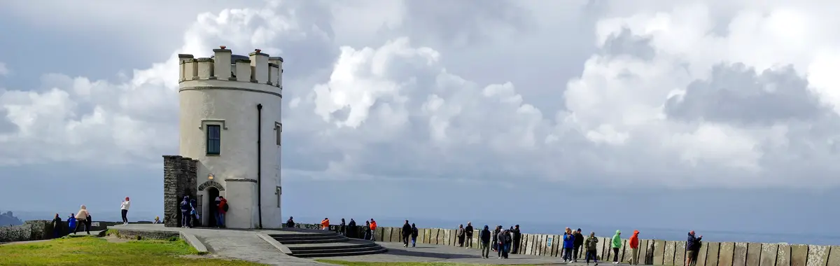
The Cliffs of Moher on the Atlantic Coast Route
Photo: Berthold Werner / Wikimedia Commons (CC BY-SA 4.0)

Atlantic Coast Route

Atlantic Coast RouteROSSLARE HARBOURDERRY/LONDONDERRY

The big one — the cyclist's counterpart to the Wild Atlantic Way, around 2,300 km up Ireland's wild south and west seaboard for fit, experienced tourers. From the ferry port at Rosslare Harbour in the south-east it works west through Cork and Kerry, past the limestone Burren and the Cliffs of Moher in Co. Clare, the inlets of Connemara, and the Slieve League sea-cliffs of Donegal, before reaching Derry/Londonderry near the Northern Ireland border. It shares the same landscapes as the Wild Atlantic Way driving route but uses very small roads with little traffic — they are not the same route. Hard: long, hilly and exposed to Atlantic wind and rain, mostly on quiet rural roads with only short greenway sections.

2,300 km18–24 daysHard
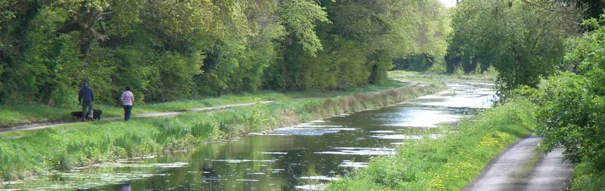
The Royal Canal Greenway on the Galway to Dublin Cycleway
Photo: Silverblaster / Wikimedia Commons (CC BY-SA 3.0)

Capitals Route

Galway to Dublin CyclewayDUBLINGALWAY

Ireland's flat coast-to-coast — the all-abilities midlands crossing, signed end to end as the Galway to Dublin Cycleway, and the easy counterpoint to EV1's wild Atlantic. From Dublin in the east it runs 231 km west across the flat midlands to Galway city, with around 60% of it traffic-free: the Dublin-to-Athlone half rides the Royal Canal Greenway towpath and the Old Rail Trail (a former railway line), past Mullingar, Athlone and the River Shannon, before quiet rural roads carry it on to Galway. Easy: virtually no hills, and the largest single stretch is dedicated, car-free greenway — a beginner-friendly introduction to bikepacking Ireland.

231 km3–5 days60%car-freeEasy
Before you rideIreland, the practical bits

What every bikepacker asks about Ireland.

Is wild camping allowed in Ireland?

Not as a legal right. Ireland — north and south — has no "right to roam", so all land access is at the landowner's discretion, and wild camping is technically not permitted without the landowner's permission. In practice, low-impact, leave-no-trace overnighting is widely tolerated in remote upland and coastal areas if you stay discreet: pitch away from houses, farmland and roads, arrive late and leave early, and follow Leave No Trace principles. National parks and nature reserves generally prohibit or restrict camping, so use designated campsites near towns where you can.

Which season is best for bikepacking Ireland?

May to September, with May, June and September the sweet spot — longest daylight, the driest months, fewer midges and lighter tourist traffic on the Atlantic coast. Ireland's climate is mild and maritime, so summer highs sit broadly around 15–20 °C and it's rarely hot; the defining factor is wind and rain off the Atlantic, not heat, and it can be wet and windy in any month. Avoid November to March for short days, frequent rain and exposed Atlantic gales, and note that July and August are the domestic-holiday peak on the west coast, with busier roads and accommodation.

Any cycling regulations I should know?

The biggest one for continental and US riders: ride on the LEFT — Ireland drives on the left. Helmets and hi-vis are recommended but not legally required at any age. A red rear reflector is required at all times, and during "lighting-up time" (about half an hour after sunset to half an hour before sunrise) you must run a white or yellow front light and a red rear light, both visible a reasonable distance. Obey traffic lights and signs, and don't cycle on footpaths unless it's a designated cycle track. A fixed-charge cycling offence — no lights at night, breaking a red light, cycling on a footpath — is a €40 fine, rising 50% if unpaid within 28 days.

What should I expect as a bikepacker in Ireland?

Two very different signed EuroVelos: a long, demanding on-road Atlantic seaboard route (EV1, ~2,300 km, for experienced cyclists) and a flat, roughly 60%-traffic-free midlands crossing (EV2, 231 km, all-abilities Dublin↔Galway). The network is mostly quiet rural roads stitched together with greenways built on old railways and canal towpaths. Remember to ride on the left. Irish Rail carries bikes, but Intercity services require an advance online bicycle reservation and spaces are limited, so plan rail legs ahead and check current policy. Resupply is good in towns and villages, but the remote Atlantic stretches — Connemara, Donegal, parts of the south-west — can be sparse, so carry food and water on long coastal days. For overnights it's B&Bs, hostels and campsites along both routes, with no formal cyclist-bed accreditation, so book ahead in peak summer on the west coast.

READY WHEN YOU ARE

Pick the route. We'll plan the rest.

Drop a EuroVelo into the Bikepackia planner and turn the line on the map into rideable days — surface-aware routing, elevation, water, food and a bed every night.